Contact me via WhatsApp Chat with Catalina on WhatsApp

Tag: Upper and Lower Egypt

  • The Nile: The River That Created Egypt

    The Nile: The River That Created Egypt

    A Civilisation Built on a River

    If Egypt exists where it does, as we explored earlier, it is because of the Nile. But the river did far more than make life possible. It created the conditions for the longest-lasting civilisation in human history.

    For more than three millennia, from the early dynastic period around 3100 BCE until the Roman annexation of Egypt in 30 BCE, Egyptian civilisation maintained a remarkable cultural and political continuity. Dynasties rose and fell, capitals shifted, and foreign rulers occasionally appeared, yet the fundamental structure of Egyptian society—its religion, language, administration, and relationship with the Nile—remained recognisably the same.

    Few civilisations in history display such extraordinary longevity within the same geographical and cultural framework. The explanation lies not only in political organisation or religious tradition, but above all in geography. Egypt was shaped by a landscape unlike any other: a narrow fertile corridor carved by the Nile through vast surrounding deserts.

    Without the Nile, Egypt would have been an extension of the Sahara.

    With it, the land became one of the most productive agricultural regions of the ancient world. Each year the river flooded its banks, depositing fertile black silt that renewed the soil and made stable agriculture possible.

    It is no coincidence that the ancient Egyptians called their land Kemet, meaning “the Black Land,” referring to the dark fertile soil created by the flood. Beyond this narrow ribbon lay Deshret“the Red Land,” the immense deserts that surrounded and protected the valley.

    In this sense, Egypt was not simply a country beside a river. It was a civilisation created by one.

    The Three Seasons of the Nile

    The rhythm of Egyptian life followed the annual cycle of the river. The ancient Egyptian calendar was divided into three agricultural seasons, each determined by the behaviour of the Nile.

    Akhet — The Flood Season

    The first season, Akhet, lasted roughly from June to September. During this time the Nile overflowed its banks as rainfall from the Ethiopian highlands fed the Blue Nile.

    The floodwaters spread across the valley, covering fields and depositing the fertile silt that made Egyptian agriculture possible. Although farming paused during this period, the flood was welcomed as a divine gift.

    The abundance of the river was personified by the god Hapi, who symbolised fertility and prosperity.

    Peret — The Growing Season

    Once the waters receded, the second season began: Peret, the season of emergence and growth.

    Farmers ploughed the softened soil and planted crops such as wheat, barley, and flax. Irrigation channels carried water to the fields, allowing plants to grow throughout the valley.

    This was the moment when the miracle of the Nile revealed its full power. From a narrow ribbon of land, Egypt could produce food in abundance.

    Shemu — The Harvest Season

    The final season, Shemu, was the harvest season, extending roughly from March to May.

    Grain was gathered and stored in granaries, forming the agricultural surplus that supported the Egyptian state. That surplus fed cities, priests, craftsmen, and the labour force that built the pyramids and temples.

    Remarkably, the same agricultural rhythm shaped Egyptian life for thousands of years and is still recognisable in the country today.

    The Nile as Egypt’s First Highway

    Aerial view of the Nile River cutting through the desert landscape of Upper Egypt
    From the air, the Nile reveals its true nature — a narrow corridor of water and life crossing the vast Egyptian desert Photograph by Catalina Garay

    The Nile was not only the source of life and agriculture. It was also Egypt’s first great transportation system.

    The river flows naturally from south to north, descending from the highlands of East Africa toward the Mediterranean Sea — a geographical phenomenon explored in more detail in our article Why Does the Nile Flow North.

    At the same time, the prevailing winds of the Nile valley blow from north to south.

    This rare geographical balance created a natural navigation system. Boats travelling north could simply follow the current of the river, while boats travelling south could raise their sails and use the steady northern winds.

    This allowed movement in both directions along the river long before the construction of roads or modern infrastructure. Merchants, officials, pilgrims, and travellers moved along this watery corridor carrying goods, ideas, and traditions from one end of the country to the other.

    Even today, traditional sailing boats such as feluccas and dahabiyas still rely on this same natural relationship between current and wind.

    The Nile and the Birth of the Egyptian State

    Because nearly every settlement developed along the same river corridor, the Nile also shaped Egypt’s political organisation.

    Over time two major regions emerged:

    • Upper Egypt, the southern Nile valley

    • Lower Egypt, the northern Nile delta

    Around 3100 BCE, these regions were unified under a single ruler, traditionally identified as Narmer, marking the birth of the Egyptian state.

    The river itself made this unity possible. Communication, administration, and trade all followed the same geographical axis. Few ancient civilisations possessed such a clear natural structure for political cohesion.

    The Nile as a Sacred Landscape

    For the ancient Egyptians the Nile was far more than a physical river. It was a sacred presence woven into religion, myth, and cosmology.

    The annual flood symbolised rebirth and renewal. The myth of Osiris, god of the afterlife, reflected this idea: life emerging again after death, just as the flood renewed the land each year.

    Temples were often aligned with the river, and sacred processions moved along its waters during religious festivals. The Nile therefore shaped not only agriculture and politics but also the spiritual imagination of Egypt.

    The River That Still Defines Egypt

    Thousands of years later, the Nile continues to define Egypt’s geography and life.

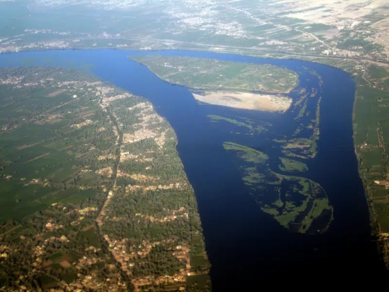
    Modern cities, agriculture, and transportation still follow the same narrow valley that sustained ancient civilisation. From space, Egypt still appears as a striking contrast: a thin green ribbon running through a vast desert.

    Travelling along the Nile today reveals a landscape that has changed remarkably little over millennia,  something beautifully described in Nile Narratives: A Timeless Journey Through the Heart of Egypt.

    Temples, villages, palm groves, and desert cliffs still follow the same ancient rhythm of the river.

    Perhaps the real question is not how Egypt used the Nile, but how the Nile shaped Egypt itself.

    The deeper question, as Dr Watson might observe, is this: did a civilisation grow beside the Nile, or did the Nile itself create it?

  • Why Egypt Exists Where It Does

    Why Egypt Exists Where It Does

    The River, the Deserts, and the Geography That Created a Civilization

    Standing on the banks of the Nile, it is easy to forget that Egypt exists in one of the most unforgiving landscapes on Earth. Beyond the narrow ribbon of green that follows the river lies an immense expanse of desert stretching across thousands of kilometres. Yet precisely here, in this unlikely environment, one of the longest-lasting civilisations in human history emerged.

    More than two thousand years ago, the Greek historian Herodotus, writing in the 5th century BC, captured this reality in a simple but powerful phrase:

    “Egypt is the gift of the Nile.”

    What he meant was not merely poetic admiration. Egypt did not emerge by chance. Its existence is the result of a remarkable geographical balance between river, desert, climate, and trade routes. The Nile made life possible, while the surrounding deserts shaped the boundaries and stability of the civilisation that grew along its banks.

    Understanding why Egypt exists where it does means understanding the landscape itself.

    The Nile’s northward course is one of the defining geographical features of Egypt, explained in detail in Why Does the Nile Flow North?

    The Nile: A River That Created a Country

    Local people harvesting river plants from small boats along the Nile in Egypt
    Local workers collecting river vegetation from traditional boats on the Nile in Egypt.

    At the heart of Egypt lies the Nile River, one of the most remarkable waterways on Earth. The Nile is a major north-flowing river in northeastern Africa that empties into the Mediterranean Sea. At 7,088 kilometres in length, it is traditionally considered the longest river in the world.

    Despite its great length, the volume of water it carries is far smaller than that of other major rivers such as the Amazon or the Congo, whose tropical basins receive much heavier rainfall.

    What makes the Nile extraordinary is not its size alone but the role it played in shaping human civilisation. Each year the river flooded its banks, depositing nutrient-rich silt across the valley. This natural cycle transformed a narrow corridor of land into one of the most productive agricultural regions of the ancient world.

    Crops such as wheat and barley flourished, sustaining populations and allowing cities to develop along the river.

    Without the Nile, Egypt would simply be desert. With it, the land became the cradle of a civilisation that endured for more than three millennia.

    A River Shaped by Deep Geological Time

    Although the Nile seems eternal, geologically speaking it is a relatively young river. The river has flowed along roughly its present course for only about 12,000 years, after climatic changes at the end of the last Ice Age reshaped the drainage systems of northeastern Africa.

    Earlier geological periods saw very different river systems across the region. Only when climatic conditions stabilised did the Nile valley form the continuous river corridor we recognise today.

    In this sense, the landscape that allowed Egyptian civilisation to flourish is itself the result of relatively recent geological change.

    The Name of the Nile

    The name “Nile” carries its own long linguistic journey.

    The English word “Nile” derives from the Latin Nilus, which itself comes from the Ancient Greek Νεῖλος (Neilos). The Greek term may ultimately originate from the Semitic word naḥal, meaning “river” or “valley stream.”

    Ancient Egyptians themselves used different names for the river, often referring to it simply as Iteru, meaning “the river.”

    For them the Nile was not merely a geographical feature. It was the defining element of their world.

    A Green Corridor Through the Desert

    Seen from above, Egypt appears as a striking contrast. A thin band of fertile green land follows the Nile through a vast sea of sand and stone.

    This valley is rarely more than 10 to 20 kilometres wide, yet it supported millions of people throughout ancient history. Every settlement, temple, and agricultural field depended on the river’s presence.

    The Nile therefore functioned not only as a source of water but also as Egypt’s main highway. Boats travelling along the river connected cities, temples, markets, and villages across hundreds of kilometres.

    In this sense the Nile was more than a river. It was the spine of the country, the axis along which Egyptian civilisation developed.

    A River and a Wind That Made Travel Possible

    One of the most remarkable geographical features of the Nile is the natural system that made navigation possible for thousands of years.

    The river flows from south to north, descending gradually from the highlands of East Africa toward the Mediterranean Sea. At the same time, the prevailing winds in Egypt blow in the opposite direction, from north to south.

    This unique combination created a natural transportation system long before engines or modern infrastructure existed.

    Boats travelling northward could simply follow the current of the river.

    Boats travelling southward could raise their sails and use the steady northern winds to move against the current.

    Thanks to this natural balance between river flow and wind direction, ancient Egyptians were able to navigate the Nile with remarkable efficiency. Traders, officials, pilgrims, and travellers could move along the river in both directions using simple sailing vessels.

    This geographical advantage played a decisive role in the development of Egyptian civilisation. The Nile became not only a source of water and fertile soil but also the primary highway of the country.

    Even today, traditional sailing boats such as feluccas and dahabiyas continue to rely on this same natural relationship between river current and prevailing winds.

    The Deserts That Protected Egypt

    Surrounding the Nile valley are vast desert regions that shaped Egypt’s historical stability.

    To the west lies the Western Desert, part of the Sahara and one of the largest desert regions on Earth. Within it are dramatic landscapes such as the White Desert, the Black Desert, and the immense dune fields of the Great Sand Sea, punctuated by ancient oasis settlements including Siwa, Bahariya, Farafra, Dakhla, and Kharga.

    To the east stretches the Eastern Desert, a rugged mountainous region between the Nile and the Red Sea. This landscape contains ancient mining areas and caravan routes linking the Nile with Red Sea ports used in antiquity for trade with Arabia, East Africa, and India.

    Further north lies the Sinai Peninsula, a land bridge between Africa and Asia with its own unique desert mountains and plateaus.

    Together these desert regions created natural barriers around the Nile valley. While not impossible to cross, they discouraged large-scale invasions and helped protect the civilisation that developed along the river.

    A Natural Corridor Between Continents

    Although the deserts protected Egypt, they also helped define its position as a crossroads between continents.

    The Nile valley formed a natural corridor linking central Africa with the Mediterranean world. Through the Sinai Peninsula Egypt connected with the Near East and the Levant, while Red Sea ports linked the Nile to maritime routes reaching Arabia, East Africa, and India.

    Merchants, diplomats, pilgrims, and travellers all moved through this landscape, following routes shaped by geography thousands of years earlier.

    A Landscape That Shaped a Civilization

    Ancient Egyptian society developed in close harmony with the rhythms of the Nile and the structure of the surrounding land.

    Agriculture depended on the annual flood. Cities rose along the riverbanks. Temples were aligned with the movement of the sun and the flow of the river.

    Even the way Egyptians described their own country reflected this geography.

    River-Based Orientation

    Ancient Egyptians did not orient themselves primarily by north and south but by the direction of the river.

    • Upstream (south) was called Upper Egypt

    • Downstream (north) was called Lower Egypt

    The Nile defined orientation, agriculture, religion, and daily life. In many ways Egypt was not simply a country with a river. It was a civilisation built around one.

    The Same Geography Still Defines Egypt Today

    Thousands of years later the same geographical structure continues to shape Egypt.

    Modern cities, agriculture, and transportation still follow the Nile valley. Travellers exploring the country today move along the same corridor that ancient Egyptians used thousands of years ago.

    Travelling along the river today still reveals the same landscape that shaped Egyptian civilisation, as described in Nile Narratives: A Timeless Journey Through the Heart of Egypt.

    Sailing between Aswan and Luxor, watching the river pass temples, villages, and desert cliffs, one experiences the same landscape that once sustained pharaohs, traders, and pilgrims.

    The geography that created Egypt has never truly changed.

    The Nile still flows north. The deserts still frame the valley. And the narrow green corridor along the river remains the heart of the country.

  • Why Does the Nile Flow North?

    Why Does the Nile Flow North?

    Understanding the Geography Behind One of the World’s Most Extraordinary Rivers

    Standing on the banks of the Nile for the first time often brings a moment of surprise. The river moves steadily northward, eventually emptying into the Mediterranean Sea. On a map this can feel almost counter-intuitive, as the river appears to flow “upward” toward the top of the page.

    Yet the Nile is not behaving unusually at all. It is simply following the most basic rule governing every river on Earth: gravity.

    Water always flows from higher elevation to lower elevation. The Nile flows north because the highlands of East Africa sit far above the Mediterranean coast, creating a natural slope that guides the river toward the sea.

    This simple geographical fact shaped the development of one of the most remarkable civilisations in human history.

    Rivers Follow Gravity, Not Compass Directions

    Many people assume rivers normally flow south, but this is a misconception. Rivers have no preferred direction on a compass. Their course is determined entirely by the topography of the land they cross.

    If the land slopes northward, the river will flow north. If the terrain slopes east, west, or south, the river will follow that path instead.

    The Nile happens to flow north because the interior of Africa is elevated compared to the Mediterranean coastline. From its sources in the highlands, the river gradually descends across thousands of kilometres until it reaches the sea.

    Where the Nile Begins

    The Nile does not begin at a single spring but in a vast network of lakes, rivers, and rainfall across eastern and central Africa.

    Two great tributaries form the main river.

    The White Nile

    The White Nile originates in the Great Lakes region of Africa. Lake Victoria is commonly considered its principal source, although several smaller rivers feed into the lake itself.

    From there the White Nile flows through Uganda and South Sudan, providing a steady and reliable supply of water to the Nile system.

    The Blue Nile

    The Blue Nile begins at Lake Tana in the Ethiopian highlands. Seasonal monsoon rains in Ethiopia dramatically increase its volume each year.

    In ancient Egypt these rains produced the famous annual flooding of the Nile, which deposited fertile silt along the riverbanks and allowed agriculture to flourish in an otherwise arid land.

    The Blue Nile and the White Nile meet in Khartoum, Sudan, where the two rivers merge before continuing their journey north toward Egypt.

    The Countries of the Nile

    The Nile travels through a remarkable portion of the African continent.

    Countries the main river flows through

    The principal course of the Nile passes through four countries:

    • Uganda
    • South Sudan
    • Sudan
    • Egypt

    Countries belonging to the Nile Basin

    However, the full Nile basin — the vast region whose rainfall eventually feeds the river — includes eleven countries:

    • Egypt
    • Sudan
    • South Sudan
    • Ethiopia
    • Uganda
    • Kenya
    • Tanzania
    • Rwanda
    • Burundi
    • Democratic Republic of Congo
    • Eritrea (partially connected through tributaries)

    This enormous watershed makes the Nile one of the most internationally shared river systems in the world.

    The Nile and the Birth of Egyptian Civilisation

    By the time the Nile reaches Egypt it has already travelled thousands of kilometres across Africa. Yet its final stretch may be the most historically significant.

    Across the Egyptian desert the river forms a narrow ribbon of fertile land surrounded by vast arid landscapes. For thousands of years this green corridor made agriculture, settlements, and cities possible.

    Temples, towns, and fields developed along the banks of the river, making the Nile the central lifeline of Egyptian civilisation.

    How Ancient Egyptians Understood Direction

    Ancient Egyptians had their own distinctive way of understanding geography. Rather than orienting themselves primarily by north and south, they organised their world according to the flow of the river.

    River-Based Orientation

    • Upstream (south) was called Upper Egypt
    • Downstream (north) was called Lower Egypt

    These names reflect elevation rather than compass direction.

    For the ancient Egyptians the Nile was not simply a river crossing the land. It was the axis around which the entire country was organised.

    Their geography was literally river-centred thinking. The Nile defined orientation, agriculture, time, transportation, and even religious symbolism. The annual flood determined the agricultural calendar, while the river itself served as the primary route linking cities, temples, and communities.

    In this sense, the Nile was far more than landscape. It was the structure of Egyptian life.

    Experiencing the Nile Today

    For travellers today, the Nile remains the thread connecting Egypt’s landscapes, history, and culture.

    Between Aswan and Luxor, the river flows past ancient temples, small villages, palm groves, and desert cliffs that have witnessed thousands of years of human history.

    Sailing the Nile offers one of the most meaningful ways to experience Egypt. Travellers can explore the river aboard:

    • traditional felucca sailing boats, offering an authentic and peaceful journey
    • elegant dahabiya vessels, combining classic sailing with comfort and spacious decks

    Both experiences reveal how the Nile continues to shape life along its banks, just as it did in the time of the pharaohs.

    A River Shaped by Deep Time

    The Nile’s northward journey is ultimately the result of millions of years of geological change. The uplift of the East African highlands created the slopes that still guide the river today.

    Long before pyramids or temples existed, the landscape itself had already determined the direction of Egypt’s future.

    Sometimes the forces that shape civilisations are not political or cultural at all.

    Sometimes they begin with something as simple — and as powerful — as gravity guiding a river toward the sea.